How to use a compass
How to use a compass
Magnetic Declination
Unfortunately, sometimes, for some quite often,
it is even more complicated. There is something called magnetic declination.
You see, the compass is pointing towards the magnetic north pole, and the
map is pointing toward s the geographic north pole, and that is not the
same place. 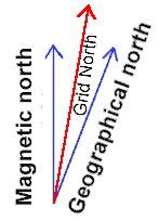 To
make things even more complicated, there is on most hiking-maps something (that
is very useful) called the UTM-grid. This grid doesn't have a real north
pole, but in most cases, the lines are not too far away from the other north.
Since this grid covers the map, it is convenient to use as meridians.
To
make things even more complicated, there is on most hiking-maps something (that
is very useful) called the UTM-grid. This grid doesn't have a real north
pole, but in most cases, the lines are not too far away from the other north.
Since this grid covers the map, it is convenient to use as meridians.
On most orienteering maps (newer than the early 70's), this is corrected, so
you won't have to worry about it. But on topographic maps, this is a problem.
First, you'll have to know how large the declination is, in degrees. This
depends on where on the earth you are. So you will have to find out before you
leave home. Or somewhere on the map, it says something about it. One thing you
have to remember in some areas, the declination changes significantly, so you'll
need to know what it is this year.
If you are using a map with a UTM-grid,
you want to know how this grid differs from the magnetic pole.
When you are taking out a course, you will do that more or less as
described in lesson
2,
 but this time, you must also look out so that you don't align the orienting
lines with the grid lines pointing west or east, or south for that matter.
When you have taken out a course like you've learned, you must add or subtract an
angle, and that angle is the angle you found before you left home, the angle
between the grid lines or meridians and the magnetic north.
but this time, you must also look out so that you don't align the orienting
lines with the grid lines pointing west or east, or south for that matter.
When you have taken out a course like you've learned, you must add or subtract an
angle, and that angle is the angle you found before you left home, the angle
between the grid lines or meridians and the magnetic north.
 The
declination is given as e.g. "15 degrees east". When you look at the
figure, you can pretend that plus is to the right, or east, and minus is to the
left and west. Like a curved row of numbers. So when something is more than zero
you'll subtract to get it back to zero. And if it is less, you'll add.
So in this case you'll subtract 15 degrees to the azimuth, by turning the
compass housing, according to the numbers on the housing. Now, finally, the
direction of travel-arrow points in the direction you want to go. Again, be
careful to aim at some distant object and off you go.
The
declination is given as e.g. "15 degrees east". When you look at the
figure, you can pretend that plus is to the right, or east, and minus is to the
left and west. Like a curved row of numbers. So when something is more than zero
you'll subtract to get it back to zero. And if it is less, you'll add.
So in this case you'll subtract 15 degrees to the azimuth, by turning the
compass housing, according to the numbers on the housing. Now, finally, the
direction of travel-arrow points in the direction you want to go. Again, be
careful to aim at some distant object and off you go.
You may not need to find the declination before you leave home, actually.
There is a fast and pretty good method to find the declination where ever you
are. This method has also the advantage that corrects for local conditions that
may be present (I am thankful towards Jim Cross who pointed this out to me).
This is what you do:
- Determine by map inspection the grid azimuth from your location to a know,
visible, distant point. The further away, the more accurate it gets. This
means you have to know where you are, and be pretty sure about one other
feature in the terrain.
- Sight on that distant point with the compass and note the magnetic
azimuth. You do that by turning the compass housing so that it is aligned
with the needle. You may now read the number from the housing where it meets
the base of the direction of travel-arrow.
- Compare the two azimuths. The difference is the declination.
- Update as necessary. You shouldn't need to do this very often, unless you
travel in a terrain with lots of mineral deposits.
There are a few riddles and rhymes to help you remember whether you should
add or subtract. I don't know them. If you live in an area where you don't go
far for it to change between east and west, it is so small you wouldn't need to
worry about it anyway. So it's best to just remember whether you should add or
subtract.
Uncertainty
You can't always expect to hit exactly what you
are looking for. In fact, you must expect to get a little off course.
How much you get off course depends very often on the things around you. How
dense the forest is, fog, visibility is a keyword. And of course, it
depends on how accurate you are. You do make things better by
being careful when you take out a course, and it is important to aim as far
ahead as you can see.
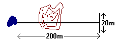 In normal forest conditions we say that as a rule of thumb, the uncertainty is
one tenth of the distance traveled. So if it is like in the figure, you go 200
meters on course, it is possible that you end up a little off course, 20 meters
or so. If you're looking for something smaller than 20 meters across, there is a
chance you'll miss. If you want to hit that rock in our example you'll need to
keep the eyes open!
In normal forest conditions we say that as a rule of thumb, the uncertainty is
one tenth of the distance traveled. So if it is like in the figure, you go 200
meters on course, it is possible that you end up a little off course, 20 meters
or so. If you're looking for something smaller than 20 meters across, there is a
chance you'll miss. If you want to hit that rock in our example you'll need to
keep the eyes open!
In the open mountain areas, things are of course a lot easier when you can
see far ahead of you.
This was the last of the lessons you should know. But more lessons
are upcoming. Now it is time to log out and get into the backyard, and then
backcountry. Try it out! That is after all, the only way to learn this properly.
Good Luck!
I said navigating in the mountains is easier. Well
that is until the fog comes. Fog can make orienteering in the mountains and in
the forest extremely difficult, and therefore, it can also be dangerous to the
un-experienced. The principles of orienteering are still the same, but there are
a few hints in the next
lesson that will help you get trained.
Home